
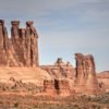
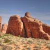
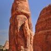
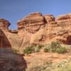
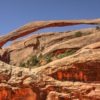
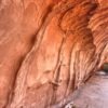
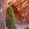
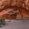
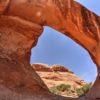
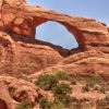
W Parku Narodowym Arches znajduje się ponad 2000 naturalnych łuków skalnych, wśród nich słynne Delicate Arch i Landscape Arch, a także różnorodne unikalne formacje geologiczne. Park zawiera najwyższą gęstość naturalnych łuków na świecie. Arches leży ponad głębokimi pokładami soli, które są główną przyczyną powstawania łuków, iglic, zbalansowanych skał, wąskich grani piaskowca i erodowanych monolitów w tym obszarze. Złoże soli powstały w niecce Paradox na płaskowyżu Kolorado ponad 300 milionów lat temu i miejscami ma tysiące metrów grubości. Później złoże soli zostało pokryte żwirami powstałymi podczas wypiętrzania Uncompahgre na północny wschód. W okresie wczesnej jury (około 210 mln lat temu) w regionie panowały warunki pustynne i powstała rozległą warstwę piaskowca Navajo. Na niej znajdują się piaskowce Entrada naniesione przez rzeki i wiatr około 140 mln lat temu. Na końcu powstała gruba na 1500 m warstwa młodszych osadów, która w większości całkowicie zerodowała do dzisiaj. Łuki skalne w parku powstają w piaskowcach formacji Entrada. Ciężar osadów upłynnił złoża soli i doprowadził do wypchnięcie warstw skał do kopuł solnych i „solnych antyklin” – liniowych obszarów wyporu. W niektórych miejscach warstwy piaskowca zostały obrócone o 90 stopni. Jedno z takich przemieszczeń o długości 760 m, uskok Moab, widoczny jest ponad centrum dla odwiedzających. Z biegiem czasu woda wnikała pod powierzchnię, w pęknięcia i szczeliny pomiędzy warstwami. Lód i woda w szczelinach kruszyły otaczającą skałę, odłamując kawałki, a wiatr usuwał luźne cząsteczki. Pozostała seria wolno stojących wąskich grani. Wiatr i woda atakowały je nadal rzeźbiąc w nich łuki i inne fantastyczne formy.[:en]
Arches National Park contains more than 2,000 natural sandstone arches are located in the park, including the well-known Delicate Arch and Landscape Arch, as well as a variety of unique geological formations. The park contains the highest density of natural arches in the world. The national park lies above an underground evaporite layer or salt bed, which is the main cause of the formation of the arches, spires, balanced rocks, sandstone fins, and eroded monoliths in the area. Deposited in Paradox Basin of Colorado Plateau over 300 mln years ago this salt bed is thousands of meters thick in places. Later, the salt bed was covered with debris eroded from the Uncompahgre Uplift to the northeast. During the Early Jurassic (about 210 Mya), desert conditions prevailed in the region and the vast Navajo Sandstone layer was deposited. An additional sequence of stream-laid and windblown sediments, the Entrada Sandstone (about 140 Mya), was deposited on top of the Navajo. Eventualy 1,500 m of younger sediments were deposited but these have been mostly eroded away. Remnants of the cover exist in the area including exposures of the Cretaceous Mancos Shale. The arches of the area are developed mostly within the Entrada formation. The weight of this cover caused the salt bed below it to liquefy and thrust up layers of rock into salt domes and “salt anticlines” – linear regions of uplift. In some places, they turned almost on edge. The result of one such 760 m displacement, the Moab Fault, is seen from the visitor center. Over time, water seeped into the surface cracks, joints, and folds of these layers. Ice formed in the fissures, expanding and putting pressure on surrounding rock, breaking off bits and pieces. Winds later cleaned out the loose particles. A series of free-standing fins remained. Wind and water attacked these fins until, in some, the cementing material gave way and chunks of rock tumbled out. Many damaged fins collapsed. Others, with the right degree of hardness and balance, survived despite their missing sections. These became the famous arches.[:]
Leave a Reply